TerraDT is a groundbreaking digital twin project designed to enhance our understanding of how glaciers, sea ice, vegetation, and aerosols influence the Earth’s climate. By delivering high-resolution climate impact assessments, it will provide concrete decision-making tools for local planning, such as helping determine optimal locations for shipping routes, parks, and other infrastructure. The project will leverage Europe's most advanced supercomputers to achieve unprecedented modeling accuracy.
Closely linked to the European Commission’s Destination Earth (DestinE) Climate Change Adaptation Digital Twin (Climate DT), TerraDT expands the climate twin’s modeling capabilities by integrating new components that more precisely capture the role of glaciers, sea ice, and aerosol particles. These enhancements will significantly improve the reliability of climate projections, supporting better adaptation and mitigation strategies.
In TerraDT, climate projections are made at the very high resolution of 10 km. This requires a significant amount of computing resources. The main computing platforms in the projects are CSC – IT Center for Science’s LUMI supercomputer in Kajaani, Finland, and Barcelona Supercomputing Center’s Mare Nostrum 5, located in Barcelona. Both of these are pan-European EuroHPC supercomputers.
Information to support decision-making
“The aim is to obtain information to support decision-making, for example, on how sea ice conditions impact shipping routes. What kind of effects will sea level changes or extreme weather conditions have on coastal and offshore construction and urban planning? The model also provides us with important information related to forest biodiversity and carbon sink assessment,” says Jenni Kontkanen, Development Manager at CSC – IT Center for Science, who leads the TerraDT project.
An interactive user interface is developed for TerraDT, through which users can ask concrete what-if questions. For example, how does building a park in a particular city impact temperatures or carbon sequestration? TerraDT’s high resolution and accuracy make it a practical tool for local decision-making: the effects of various phenomena can be viewed and predicted locally at a precise level.
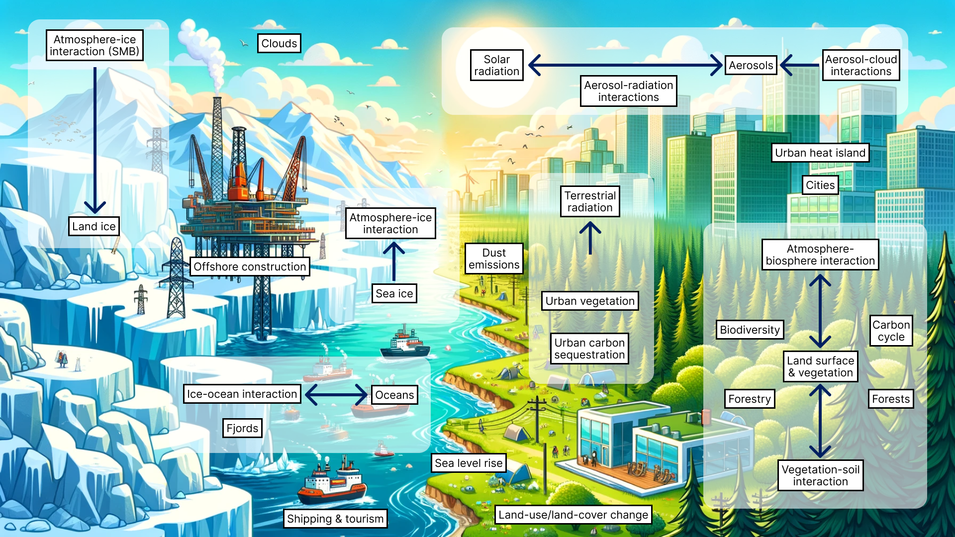
TerraDT’s components will more accurately describe the impact of glaciers, sea ice, vegetation and aerosol particles on the climate.
Collaboration of 18 European actors
The TerraDT project started at the beginning of 2025 and will last for four years. Its total budget is about 15 million euros. TerraDT is a Horizon Europe-funded research project that involves 18 organizations from all over Europe.
More on TerraDT
For more information on TerraDT.eu visit our website at TerraDT.eu (https://terradt.eu/) or contact us at info@terradt.eu