The evolution of the massive ice sheets of Antarctica and Greenland, and their contribution to global sea level rise, is influenced by a delicate interplay between the atmosphere, oceans, and ice dynamics. Yet, many of these processes unfold on scales of just a few kilometres, far smaller than what most global climate models can currently resolve.
A new level of detail for a global challenge
In the TerraDT project, researchers from the Max Planck Institute for Meteorology (MPI-M) and other European partners are addressing this limitation by coupling the kilometre-scale ICON model (Icosahedral Nonhydrostatic model) with the ice sheet model Elmer/Ice sheet model.
This next-generation coupled system will allow scientists to simulate, with unprecedented resolution the mass balance of ice sheets, the balance between snow accumulation and ice loss through melting and calving, in a global model. This is a critical step toward understanding how ice sheets evolve and how they interact with their surrounding environment and the global climate.
Capturing the complexity of precipitation
A key innovation lies in how these high-resolution models represent precipitation, i.e. rain and snow, over complex terrain. The figure below shows the annual precipitation over Antarctica as simulated by an ICON model at 2.5 km horizontal resolution, produced for the WCRP global km-scale hackathon (2025).
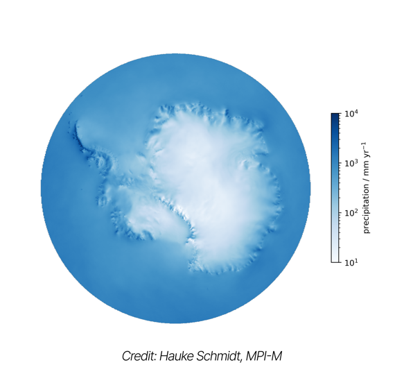
Without even displaying coastlines or elevation, the outline of Antarctica emerges naturally from the simulation, entirely shaped by how precipitation interacts with topography. The model captures an enormous range of conditions, from near-zero snowfall in the dry valleys of the Transantarctic Mountains to up to 10 metres of precipitation per year along the storm-lashed Antarctic Peninsula.
“Typical climate models used for century-long simulations still resolve the atmosphere at around 100 km,” explains Dr. Hauke Schmidt, group leader for Global Circulation and Climate at MPI-M. “At those scales, you simply can’t represent fine structures relevant for the surface mass balance of ice sheets. By moving to the kilometre scale, we expect to make an important step for understanding the current ice sheet evolution.”
Bridging the gaps between atmosphere, ocean, and ice
This coupling effort will also shed light on ice–ocean interactions, particularly in areas where small-scale dynamics play a key role, such as Greenland’s coastal glaciers and Antarctica’s floating ice shelves. Beneath these ice shelves which cover more than a million square kilometres, ocean cavities extend the Southern Ocean, yet are typically neglected in traditional models.
By simulating these systems at finer spatial resolutions, TerraDT aims to improve our understanding of how meltwater from the ice sheets affects ocean circulation, and how feedback mechanisms between the ocean and atmosphere accelerate or slow down ice loss.
Towards a more connected Earth system
This work represents a vital contribution to Destination Earth (DestinE), the European Commission’s flagship initiative to create high-precision digital replicas of the Earth system. Within this vision, TerraDT’s coupled models will, in particular, enhance the representation of the cryosphere.
As Dr. Schmidt notes, “By increasing the model resolution to the kilometre scale we’re now approaching the scales on which people experience climate.” That means these new tools won’t just improve scientific understanding, they’ll eventually make climate projections more relevant to society, from long-term sea level scenarios to regional impacts that affect coastal planning, ecosystems, and livelihoods.
A step forward for the cryosphere
While the full benefits of these models will unfold over decades, TerraDT’s technical advances lay the foundation for a future where climate and ice models truly speak the same language.
By coupling atmosphere, ocean, and ice at kilometre resolution, the project is taking a decisive step toward reducing the “deep uncertainty” that still surrounds global sea level rise and giving scientists the means to better predict the future of our planet’s frozen regions.