After its first year, TerraDT is beginning to demonstrate how next-generation climate digital twins can support more accurate, user-relevant insights for climate adaptation in line with the Destination Earth (DestinE) initiative. The TerraDT One Year On: Main Achievements in Climate Digital Twins webinar provided a comprehensive overview of the project’s progress. Bringing together leading experts and sister initiatives, the session highlighted key technical developments, early results, and emerging applications, while offering valuable insights into the challenges and opportunities shaping the next generation of climate digital twins.
Why TerraDT is needed
"While DestinE represents a major step forward in Earth system modelling, important gaps remain in the representation of key processes and in translating simulations into actionable information", says our project coordinator Jenni Kontkanen. TerraDT addresses these challenges by improving the accuracy, resolution and usability of climate simulations, bridging the gap between complex models and real-world decision-making.
Project objectives
TerraDT is built around a set of ambitious and complementary objectives:
- Developing interoperable and interactive digital twins (DTs) at global km-scale resolution
- Improving the representation of critical Earth system components, including land ice, sea ice, aerosols and land surface processes
- Creating a modular infrastructure with a flexible coupling interface to integrate new components and AI/ML-based emulators
- Delivering impact models linked to the cryosphere and land surface, with interactive capabilities for end-users
- Enabling full integration of these components into the broader DestinE framework
Progress after one year
In its first year, TerraDT has laid the technical and collaborative foundations for these objectives:
- Initial versions of key model components have been developed
- A first iteration of the general coupling interface is in place
- Early versions of interactive user interfaces for impact models have been created
- Two co-creation workshops with end-users have been conducted, focusing on sea ice and urban impact modelling
These milestones mark an important transition from concept to implementation.
Ice sheets: a missing piece in climate modelling
One of the most significant advances presented during the webinar was the work on coupling dynamic ice sheets into km-scale climate models, presented by Clemens Schannwell (Max Planck Institute for Meteorology) in our annual webinar.
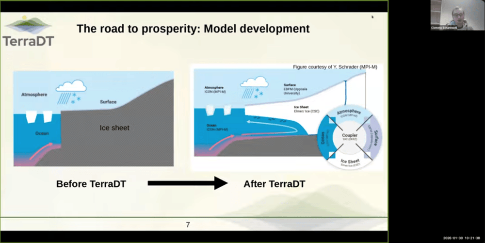
"Traditionally, ice sheets have been treated as static components in climate simulations. However, their interaction with the atmosphere and ocean plays a critical role in sea-level rise and long-term climate dynamics yet remains underrepresented" says Clemens, even in recent IPCC reports.
TerraDT is addressing this gap by enabling dynamic coupling between ice sheet models and the broader climate system. Early work includes:
- A first coupled test simulation using the YAC coupler
- New coupling strategies designed to reduce computational load
- Preparation for future km-scale coupled simulations
This work requires close collaboration across disciplines and access to Europe’s most advanced supercomputing infrastructure: an approach that sits at the core of TerraDT interdisciplinary pillars structure.
From data to decisions: interactive user interfaces
A key innovation of TerraDT lies in making complex climate data accessible and usable, explained Katri Tegel (CSC).
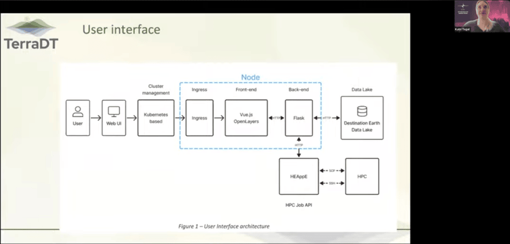
The project is developing interactive user interfaces that allow users to explore climate scenarios through maps and time-based visualisations. While such interfaces already exist, TerraDT combines them with high-performance computing and high-resolution simulations, significantly enhancing their value.
Current efforts focus on:
- Standardising data formats compatible with tools such as Python and pandas
- Streamlining data processing workflows
- Defining best practices for delivering actionable climate information
Urban heat extremes: bringing climate insights to the city scale
"Climate risks are experienced locally, yet climate models often lack the spatial resolution needed for city-level decision-making" says Inês Girão (+Atlantic). TerraDT addresses this challenge through its urban impact modelling work, targeting five pilot cities: Barcelona, Helsinki, Munich, Lisbon and Paris.
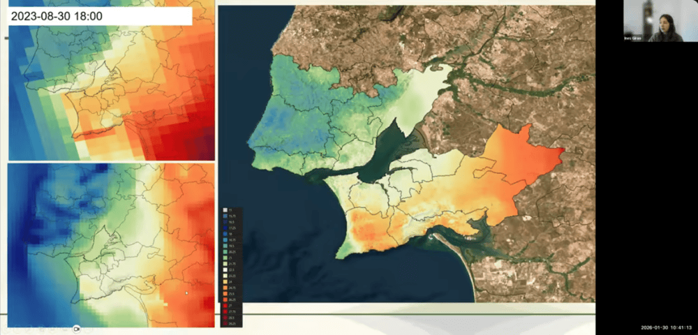
By combining multiple data sources and advanced modelling techniques, the project is working to:
- Improve the representation of local temperature variability
- Correct systematic biases, particularly in coastal areas
- Generate physically consistent, high-resolution information on heat and cold extremes
This approach will ultimately allow local stakeholders to explore different scenarios and better understand the impacts of climate variability in their specific urban contexts.
Updates from the sister projects and other initiatives in the EU climate modelling ecosystem
As Europe advances toward operational climate digital twins under Destination Earth, a growing ecosystem of complementary projects is shaping the capabilities, tools and services that will underpin this vision. Alongside TerraDT, initiatives such as UrbanAIR, WeatherGenerator and AI4PEX are making tangible progress from user-driven urban climate applications to next-generation AI weather models and enhanced Earth system simulations, highlighting how coordinated efforts are accelerating innovation across scales and domains. Here is a snapshot of each project's progress so far:
UrbanAIR
UrbanAIR is designed to deliver a user-friendly and dynamic digital twin infrastructure to support decision makers that are facing urban heat and air quality dilemmas. The project, like TerraDT, also wants to integrate into DestinE. The project has established the foundations of its digital twin, built around real decision-making needs rather than abstract modelling. This has been achieved through the development of three distinct user journeys in three core cities, with strong co-development involving local stakeholders:
- Greenery – Antwerp
- Climate extremes and hazards – Paris
- Clean Air Directive – Barcelona
The project’s technical backbone is also advancing, with progress in multiscale modelling from regional to local levels, AI-based emulators, risk handling, and uncertainty quantification. UrbanAIR is designed with modularity and interoperability in mind, supporting the reuse and broader adoption of its solutions.
WeatherGenerator
WeatherGenerator follows a different approach, focusing on the development of novel tools based on large-scale AI models for weather and climate simulations. These models have demonstrated strong performance, in some cases surpassing traditional numerical weather prediction methods. The project is developing a foundation model for the atmosphere and land components, which can be applied to a range of downstream tasks. The first version of this model is complete and currently undergoing internal testing.
The consortium includes 16 partners, primarily focused on downstream application development, effectively acting as first test end-users. The model is already capable of state-of-the-art medium-range weather forecasting, rivaling established systems. The project is now preparing for further software development and iterative refinement, with the next version of the model expected to be publicly released by the end of 2026.
AI4PEX
AI4PEX operates on longer timescales, enhancing classical Earth system models by integrating observational data through machine learning and artificial intelligence. Its objective is to improve model representation and parameterisation, ultimately reducing uncertainties in long-term climate projections.
The project combines methodological expertise in AI/ML with domain knowledge across Earth system components, including the ocean and atmosphere. This cross-disciplinary approach enables the team to address challenges from multiple perspectives and deliver integrated outcomes.
Key achievements include:
- New datasets covering land, atmosphere, and cloud structures, as well as energy and carbon-related measurements and upscaling
- Novel approaches for detecting and attributing extreme events and their drivers
- A proof of concept demonstrating the integration of machine learning into operational Earth system models
Next steps will focus primarily on advancing coupling efforts across model components.
Looking ahead
After one year, TerraDT has moved from vision to tangible development. Core components are in place, early integrations have been tested, and engagement with end-users is actively shaping the direction of the work.
The next phase will focus on scaling up: refining coupled simulations, improving resolution, and further integrating components into the DestinE ecosystem. At the same time, continued collaboration with stakeholders will ensure that the tools being developed remain relevant, usable and impactful.
By combining scientific excellence, advanced computing and user-driven design, TerraDT is contributing to a new generation of climate digital twins designed not only to simulate the Earth system, but to support the decisions needed to adapt to it.