Digital Twin of Earth system for Cryosphere, Land surface and related interactions
TerraDT, funded by the European Union under Grant Agreement 101187992, aims at enhancing the Destination Earth infrastructure by developing a Digital Twin (DT) of the Earth system for the cryosphere, land surface and related interactions. The project will improve the reliability and relevance of the climate projections and impact assessments of DestinE, which is critical for guiding climate adaptation and mitigation actions.
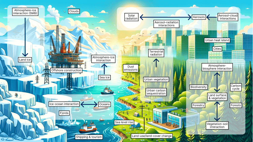
Fig 1. Earth systems impacted by TerraDT
Key objectives of TerraDT
- Building interoperable and interactive DTs, while pushing the resolution to km-scale, globally.
- Improving the descriptions of Earth system components in the DestinE climate models for land ice, sea ice, aerosols and land surface.
- Building modular infrastructure with a coupling interface that enables adding new components or AI/ML-based emulators.
- Developing impact models linked to the cryosphere and land surface to provide user-relevant information with interactive capabilities.
- Enabling the full integration of these new components and models into the DestinE framework.
Outputs of the project
The project consortium, comprising 18 partners, is cooperating to produce:
- New Digital Twin Components (DTCs) for Land Ice, Sea Ice, Aerosols, Vegetation and Land Use
- A coupling interface that allows integration with the DestinE infrastructure
- Impact Models for the cryosphere to gain insights into how land ice changes impact sea level rise and glacier retreat and to look into how sea ice impacts shipping and offshore/onshore infrastructures
- An impact model for forests to understand their influence on carbon sequestration and biodiversity
- An impact model of selected urban areas to understand carbon sequestration in cities and inform urban planning in climate extremes.
Learn more about the consortium